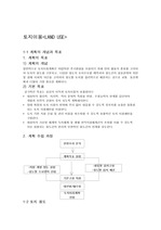
토지이용 1-1 계획의 개념과 목표 1. 계획의 목표 1) 계획의 개념 일반적으로 토지이용계획은 바람직한 주거환경을 조성하기 위해 먼저 활동의 종류를 고려하여 토지의 용도를 구분하고, 다양한 용도의 토지수요를 예측하여 용도간의 상호관게와 자연 및 경제 사회적 여건을 ..
The study area was forest landuse before development plan, however it is now changing to the resort. ... Of the landuses, the development means the changes of the soil cover and the increases of imperviousness ... The paved areas are highly polluted landuses because of high pollutant accumulation rate by vehicle activities
기후변화와 도시화는 기저유출이 하천유량에 미치는 계절별 특성에 변동성을 초래한다. 이러한 기저유출의 변동성은 수생태의 혼란을 유발할 뿐만 아니라 불안정한 수자원 관리를 초래할 수 있다. 토지이용변화는 직접유출과 기저유출에 영향을 주며, 결과적으로 다른 수문순환 요소들에..
Ten fifth streams of each landuse were selected,and each stream was divided into four microtopological ... Through this study, we find that landuse pattern in watershed region affects denitrification rates that ... aimed to investigate denitrification rates and their determinant factors in streams with different landuse
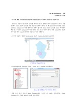
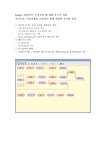
landuse의 주요필드는 OGC_FID, landuse, AREA 등이 있으며, 주요필드는 처럼 각 레이어의속성테이블에서 확인이 가능하다. places 속성테이블 주요필드 ... Landuse 분류 방법 범주화에는 명치, 순서, 간격 그리고 비율 네 가지 유형이 있다. ?명칭 범주화에서는 오브젝트의 명칭을 기준으로 카테고리를 범주화하고, ? ... 레이어 명칭 범례 항목 레이어에 사용된 명칭에는 와 같이 8개의 명칭을 사용하였으며, buildings은 11개, landuse는 4개의 소 항목으로 구성되어 있다.
편집 후 incheon.shp의 속성Table 2) 인천 행정 구역(Incheon.shp)과 토지 이용도(Landuse.shp)를 Union과 Intersect를 통해 중첩해 보고 ... 차이점을 설명하시오. a) Incheon.shp file과 Landuse.shp file을 add 한 뒤, Analysis Tools - Over lay - Itersect와 Union을 ... Union file의 속성정보를 살펴보면 incheon file의 속성정보와 landuse file의 속성정보가 합쳐져 table 내용이 두 Table의 속성정보를 합친 것보다 증가한
The study area was forest landuse before resort development, however it is now changing to the resort ... Of the landuses, the development means the changes of the soil cover and the increases of imperviousness ... The paved areas are highly polluted landuses because of high pollutant accumulation rate by vehicle activities
using landscape index based on this landuse map. ... The study made a landuse map on the study area then quantified the landscape ecologic characteristic
distance partly correlated in the case of cities in Japan, China, and the United States, and the urban landuse ... characteristics of cities in Japan, China, United States were explored with urban size, altitude, gradient, and landuse
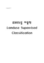
분석결과의 형태 - 적절한 부지를 1, 적절하지 않은 부지를 0로 할당한 Boolean 형식의 Raster 자료 Relief Landuse Surface: 지형경사 계산을 위해 활용 ... Relief → Surface ( 단위를 Degree 로 설정 ) → slope slope → Reclass ( 1 0-2.5 , 0 2.5-999로 설정 ) → slopereclass Landuse
본 연구에서는 시가화지역의 서로 다른 토지이용을 대상으로 식물군집에 기초한 비오톱 유형분류를 실시하고 비오톱 지도를 작성하였다. 군집분류법에 의한 비오톱 유형화는 생물군집의 서식지인 비오톱의 특성을 잘 반영한다고 할 수 있었다. 연구대상지의 비오톱유형 분류 지표는 이용..
waterbodies and predict the future impact by
stormwater runoff, the unit pollutant loads from various landuses ... research was performed
to characterize the stormwater runoff and to provide the unit loads from Toll-gate landuses